| View from West Point. |
Getting up to Mt. Home in Sunday morning, and it was a bit chilly, but the sun was out, and we were all excited to see the snow. A ton of other people were out hiking up to the snow as well. You could only access Mt. Tam by hiking on Sunday as well, as the Park Service had the roads closed due to ice! Good day to get some exercise for everyone.
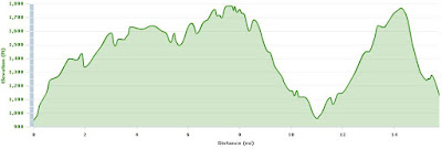
Matt Davis to West Point with some snow! by bmiller4243 at Garmin Connect - Details
The route was planned to have some fun on Matt Davis Trail, all the way to a great lookout point over Stinson Beach. You could then return the way you came for 8.5 to 9 miles, or add a bit of climbing to West Point, and get back to the parking lot for 11. Here's my Garmin maps, but I added a West Point repeat on the end, since I have my IM in three months for Texas, the rest of the group is doing late season races like Canada.
 |
| Mt. Home Inn to Pantoll via Matt Davis, then return through West Point on Old Stage Road, and back to Mt. Home inn on Old Railroad Grade. |
 | ||||
| 3,800 feet of climbing! |
Awesome run! Looking forward to more of this in the coming months!
ReplyDelete